By Beth Smith, M. Ed. | #smithingifted
One of my favorite parts of teaching gifted students is giving them opportunities to see that learning does not just happen inside one classroom, one school, or one community. Gifted learners need experiences that help them think bigger, ask better questions, and connect their learning to the real world.
That is one reason I started using Google My Maps with The Global Innovation Lab.

The Global Innovation Lab is designed to connect students and educators across communities, states, and countries so they can collaborate on real-world challenges. Our first challenge focuses on water conservation, and as teachers and classrooms join the project, I wanted a way to visually show students that they are part of something bigger.
Google My Maps gives us that visual.
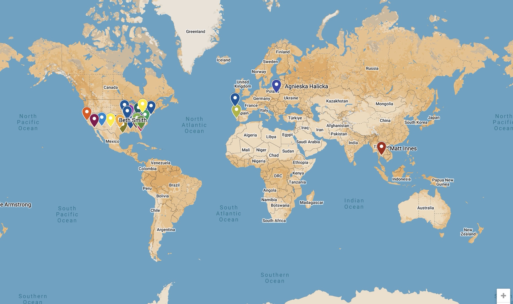
Instead of just telling students, “We are connecting with classrooms in other places,” students can actually see those connections on a map. They can see where participating teachers and students are located, compare regions, notice patterns, ask questions, and begin thinking globally.
For gifted students, that matters.
Why Google My Maps Works for The Global Innovation Lab
The Global Innovation Lab is built around collaboration, innovation, creativity, STEM, and real-world problem solving. Google My Maps supports all of those goals because it helps students visualize information geographically.
As teachers join the Global Innovation Lab, I can add their general location to the map. I do not need exact school addresses. A city, state, and country are enough to show students where our partners are located while still keeping privacy and safety in mind.
Students can then explore questions like:
- Where are our partner classrooms located?
- Are they in rural, suburban, or urban areas?
- What water issues might they experience in their region?
- How might their climate affect water conservation?
- How are their communities similar to or different from ours?
- What can we learn from students in other parts of the world?
That is where the magic happens. The map is not just decoration. It becomes a tool for inquiry.
Making Global Connections Visible
Sometimes global collaboration can feel abstract to students, especially in grades 3–5. They may understand that another country exists, but they may not fully grasp the distance, geography, climate, culture, or environmental conditions that shape life in that place.
Google My Maps helps make those connections visible.
When students see pins on a map, they begin to understand that real students in real classrooms are working on similar challenges. They can zoom in, zoom out, compare locations, and start making observations.
For The Global Innovation Lab, this helps students see themselves as part of a larger network of problem solvers.
They are not just completing a classroom assignment. They are joining a global conversation.
How I Set Up My Global Innovation Lab Map
For my Global Innovation Lab map, I use a simple system. I keep a Google Sheet with teacher and classroom information, then import that information into Google My Maps.
My spreadsheet may include columns such as:
- Teacher name
- School or organization
- City
- State or region
- Country
- Grade level
- Status
- Challenge interest
- Notes
For privacy, I recommend using city-level locations instead of exact school addresses. The purpose is to show global participation, not to identify exact student locations.
In Google My Maps, each teacher or classroom becomes a pin. Students can click on the pin to learn basic information about that partner classroom, such as the country, grade level, and challenge focus.
This setup keeps the map organized and easy to update as more educators join.
Using Layers to Organize the Map
Google My Maps allows you to use layers, which can help organize different types of information. For The Global Innovation Lab, I would not create a layer for every teacher. That would become overwhelming quickly.
Instead, layers should be used for larger categories.
For example:
- Confirmed Global Innovation Lab Members
- Interested Educators
- Water Conservation Challenge Partners
- United States Classrooms
- International Classrooms
This allows the map to stay clean and useful.
Students can turn layers on and off to compare different groups. For example, they might look only at international classrooms or only at classrooms participating in the water conservation challenge.
This gives students more control over how they analyze the information.
Why This Is Powerful for Grades 3–5 Gifted Students
Google My Maps is especially useful for 3rd–5th grade gifted learners because it combines geography, technology, research, data, and critical thinking.
Students are not just looking at a map. They are interpreting information.
They can identify patterns, make predictions, compare regions, and ask deeper questions. They can connect geography to real-world issues such as water access, drought, agriculture, climate, population, and community needs.
That type of thinking is exactly what gifted students need.
A map can become the starting point for:
- Research
- Discussion
- Writing
- STEM challenges
- Data analysis
- Design thinking
- Global collaboration
- Student presentations
It is simple enough for upper elementary students to use, but open-ended enough to support advanced thinking.
Other Ways to Use Google My Maps in the Gifted Classroom
Google My Maps is not just for The Global Innovation Lab. It can be used in so many gifted classroom projects.
1. Our Hometown Research Projects
Students can use Google My Maps to identify important places in their community. They might map historic buildings, local businesses, parks, museums, natural resources, or landmarks.
For an Our Hometown project, students could create pins that include:
- A short description
- A photo
- A historical fact
- A student-created question
- A connection to the community’s identity
This helps students understand that geography shapes how communities grow and change.
2. Literature Connections
Google My Maps can also be used with novels and reading projects. Students can map the setting of a book, the journey of a character, or important places connected to the story.
For Battle of the Books or novel studies, students could map:
- Where the story takes place
- Where the author is from
- Important events in the plot
- Real-world locations connected to the topic
- Character movement across the story
This gives students a visual way to connect reading, geography, and comprehension.
3. STEM and Environmental Challenges
Google My Maps is perfect for environmental STEM projects. Students can map local or global problems and then design solutions.
For example, students could map:
- Water sources
- Drought areas
- Flood zones
- Recycling centers
- Polluted areas
- Animal habitats
- Renewable energy sites
- Community gardens
Then they can analyze the map and ask, “What problem do we notice, and what solution could we design?”
4. Famous Innovators and Inventors
Students can create a map of innovators, inventors, scientists, engineers, artists, or leaders from around the world.
Each pin could include:
- Name
- Location
- Contribution
- Impact
- Student reflection
- Connection to modern problems
This helps students see that innovation happens everywhere, not just in one country or one time period.
5. Mystery Geography Challenges
Gifted students love puzzles and patterns, so Google My Maps can be used for mystery geography challenges. Teachers can drop pins on the map and give students clues to analyze.
Students might use the map to solve questions like:
- What do these locations have in common?
- Why might these cities have grown where they did?
- What patterns do you notice?
- What geographic features influenced these places?
- Which location would be best for a new innovation lab, and why?
This turns geography into problem solving.
6. Career and College Exploration
For older elementary gifted students, Google My Maps can also support career and college exploration. Students can map universities, trade schools, research labs, companies, museums, or career-related locations.
They can explore where certain careers are in demand and how geography connects to opportunity.
For example, students could map:
- Robotics companies
- NASA centers
- Engineering schools
- Agricultural research centers
- Water conservation organizations
- Medical schools
- Technology hubs
This helps students connect their interests to real-world pathways.
Student-Created Maps
One of the best parts of Google My Maps is that students can create their own maps. Instead of always using a teacher-created map, students can become the map designers.
A student-created map requires them to research, organize information, write clearly, and make decisions about what matters most.
Students can create maps for:
- Research projects
- Passion projects
- STEM challenges
- Historical events
- Book settings
- Community studies
- Global issues
- Innovation projects
This gives students a product that is visual, interactive, and easy to share.
Skills Students Practice
When students use Google My Maps, they are practicing far more than geography.
They are building skills in:
- Research
- Digital literacy
- Spatial reasoning
- Data organization
- Critical thinking
- Communication
- Problem solving
- Collaboration
- Creativity
- Global awareness
Those are exactly the types of skills gifted students need as they prepare for more advanced learning.
Keeping It Safe and Purposeful
When using Google My Maps with students, safety matters. I recommend using general locations instead of exact addresses, especially when mapping classrooms or student-connected projects.
Teachers should also decide ahead of time what information students can include in their pins.
For example, students might include:
- City and country
- General description
- Research facts
- Project notes
- Photos of places or objects
But they should avoid including:
- Student full names
- Home addresses
- Private contact information
- Exact student locations
- Personal details
The goal is to make learning visible without oversharing.
Why I’ll Keep Using Google My Maps
For #smithingifted, Google My Maps fits beautifully with the way I want students to learn. It supports inquiry, creativity, STEM, research, collaboration, and real-world problem solving.
For The Global Innovation Lab, it helps students see that they are part of something bigger than one classroom.
For other projects, it gives students a way to organize information, notice patterns, and present learning in a meaningful way.
Most importantly, it helps gifted students think like researchers, innovators, and global citizens.
That is the kind of learning I want more of in my classroom.
Google My Maps may look simple at first, but in a gifted classroom, it can become a powerful tool for helping students explore the world, ask deeper questions, and connect their learning to real places and real problems.
And that is exactly what #smithingifted is all about.

